Property Record
4509 Rossville Blvd, Chattanooga, TN 37407


NEARBY LISTINGS FOR SALE OR LEASE
-
-
-
-
-
No Photo
-
-
-
View all Chattanooga listings for sale on LoopNet.com
Property Detail
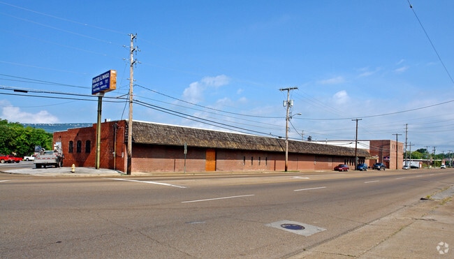
4509 Rossville Blvd
Chattanooga, TN-GA
East End Land Co Add
168I-B-009
LTS 2 3&4 BLK 207 1-16 BLK 208 EAST END LAND CO ADDN NO 1 PB2 PG22
Warehouse
Hamilton
AE
Tennessee
47065C0456G
2,3,4
2025
3.54 AC
2025
South
002300
Chattanooga
96,670 SF
DEMOGRAPHICS near 4509 Rossville Blvd
1 Mile
3 Mile
5 Mile
2024 Total Population
7,647
57,611
134,684
2029 Population
8,125
61,193
143,485
Pop Growth 2024-2029
+ 6.25%
+ 6.22%
+ 6.53%
Average Age
34
38
39
2024 Total Households
2,596
22,597
55,968
HH Growth 2024-2029
+ 6.32%
+ 6.25%
+ 6.84%
Median Household Inc
$34,368
$42,601
$44,050
Avg Household Size
2.70
2.40
2.30
2024 Avg HH Vehicles
2.00
2.00
2.00
Median Home Value
$101,437
$151,730
$174,862
Median Year Built
1948
1960
1966
Nearby Places
Map Layers
Map Styles
 Street
 Aerial
- Restaurants
- Banks
- Shops
- Fitness
- Groceries
PUBLIC TRANSPORTATION
AIRPORT
Lovell Field
DRIVE
WALK
Distance
Lovell Field
17 min
9.3 mi
Freight Ports
Georgia Ports - Savannah
DRIVE
WALK
Distance
Georgia Ports - Savannah
403 min
361.0 mi
Nearby Properties
Address
Land Use
TOTAL SIZE
Lot Size
Zoning
Address
Land Use
TOTAL SIZE
Lot Size
Zoning
728,901 SF
103.09 AC
Address
Land Use
TOTAL SIZE
Lot Size
Zoning
296,016 SF
13.36 AC
R3
Address
Land Use
TOTAL SIZE
Lot Size
Zoning
288,371 SF
9.39 AC
Address
Land Use
TOTAL SIZE
Lot Size
Zoning
43,470 SF
1.26 AC
R4
Address
Land Use
TOTAL SIZE
Lot Size
Zoning
17,742 SF
8 AC
FOR PM
Address
Land Use
TOTAL SIZE
Lot Size
Zoning
19,600 SF
14.10 AC
UR
Address
Land Use
TOTAL SIZE
Lot Size
Zoning
33.19 AC
M1
Address
Land Use
TOTAL SIZE
Lot Size
Zoning
202,748 SF
25.49 AC
M3
Address
Land Use
TOTAL SIZE
Lot Size
Zoning
90,565 SF
18.50 AC
FOR R-2
Address
Land Use
TOTAL SIZE
Lot Size
Zoning
1.61 AC
R2
Address
Land Use
TOTAL SIZE
Lot Size
Zoning
458,265 SF
62.80 AC
M1
Address
Land Use
TOTAL SIZE
Lot Size
Zoning
55,289 SF
9.33 AC
C2
Address
Land Use
TOTAL SIZE
Lot Size
Zoning
172,053 SF
8.07 AC
M1
Address
Land Use
TOTAL SIZE
Lot Size
Zoning
37,044 SF
3.88 AC
UGC
Address
Land Use
TOTAL SIZE
Lot Size
Zoning
31,548 SF
7.58 AC
R3
Address
Land Use
TOTAL SIZE
Lot Size
Zoning
41,872 SF
7.09 AC
C2
Address
Land Use
TOTAL SIZE
Lot Size
Zoning
35,364 SF
1.16 AC
M1
Address
Land Use
TOTAL SIZE
Lot Size
Zoning
15,344 SF
13.14 AC
R3
Address
Land Use
TOTAL SIZE
Lot Size
Zoning
200,911 SF
13.21 AC
M1
Address
Land Use
TOTAL SIZE
Lot Size
Zoning
89,163 SF
4.11 AC
M1
Address
Land Use
TOTAL SIZE
Lot Size
Zoning
27,000 SF
2.65 AC
UGC
Address
Land Use
TOTAL SIZE
Lot Size
Zoning
23,530 SF
1.76 AC
R4
Address
Land Use
TOTAL SIZE
Lot Size
Zoning
111,056 SF
9.89 AC
R4
Address
Land Use
TOTAL SIZE
Lot Size
Zoning
114,395 SF
5.60 AC
UR
Address
Land Use
TOTAL SIZE
Lot Size
Zoning
5,762 SF
3.16 AC
R3
Address
Land Use
TOTAL SIZE
Lot Size
Zoning
9,990 SF
1.27 AC
R4
Address
Land Use
TOTAL SIZE
Lot Size
Zoning
175,829 SF
6.36 AC
M1
Address
Land Use
TOTAL SIZE
Lot Size
Zoning
34,702 SF
1.24 AC
UGC
Address
Land Use
TOTAL SIZE
Lot Size
Zoning
51,724 SF
4.08 AC
Address
Land Use
TOTAL SIZE
Lot Size
Zoning
30,438 SF
1.15 AC
UGC
The World's #1 Commercial Real Estate Marketplace
Connect with us
© 2026 CoStar Group
The information above has been obtained from sources believed reliable. While we do not doubt its accuracy we have not verified it and make no guarantee, warranty or representation about it. It is your responsibility to independently confirm its accuracy and completeness. Any projections, opinions, assumptions, or estimates used are for example only and do not represent the current or future performance of the property. The value of this transaction to you depends on tax and other factors which should be evaluated by your tax, financial, and legal advisors. You and your advisors should conduct a careful, independent investigation of the property to determine to your satisfaction the suitability of the property for your needs.